Filter: Categories of Wisconsin Historical Images
Filter: County of Adams
Filter: Subject of land
Filter: Categories of Wisconsin Historical Images
Filter: County of Adams
Filter: Subject of land
| Date: | |
|---|---|
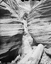
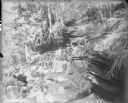
| Description: | Rock formations along the top of Fort Rider. The photographer's wet negative plate equipment is at foot of the rock formation. |

| Date: | |
|---|---|
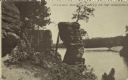
| Description: | View of a large geological rock formation at the base of a river or lake. |
| Date: | |
|---|---|
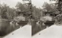
| Description: | Stereograph of the steamboat the "Dell Queen" at Chapel Gorge. A woman and a young child sit on the shoreline. |
| Date: | |
|---|---|
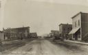
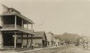
| Description: | Photographic postcard of Main Street. People, automobiles, and horse-drawn vehicles line the dirt-covered street and sidewalks. A Gold Medal Flour billboar... |

| Date: | |
|---|---|
| Description: | Photographic postcard of a geological rock formation. Side view of the snow-covered bluff and rocks surrounded by trees. Two children stand on a ledge next... |
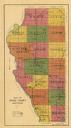
| Date: | 1916 |
|---|---|
| Description: | This early 20th century map of Adams County, Wisconsin, shows the township and range grid, towns, sections, cities and villages, roads, railroads, lakes an... |
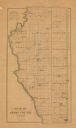
| Date: | 1900 |
|---|---|
| Description: | This map of Adams County, Wisconsin, from E.B. Foote's Plat book of Adams County, Wisconsin, 1900, shows the township and range grid, towns, sections, citi... |

| Date: | 1930 |
|---|---|
| Description: | View of resort cottages near a lake. A group of vacationers are sitting on the lawn and porch. A birdhouse on a tall post is among trees on the right. Hill... |
| Date: | |
|---|---|
| Description: | View down north Main Street. The Hotel Wrchota is on the left. Horse-drawn vehicles and automobiles are further down the street. A tree-covered hill is in ... |

| Date: | |
|---|---|
| Description: | Elevated view of Friendship, with houses and commercial buildings. |

| Date: | |
|---|---|
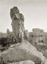
| Description: | View of Friendship Mound — a rocky outcropping, from the road below. |

| Date: | |
|---|---|
| Description: | Hand-colored postcard of Rabbit Rock — a rocky outcropping with two towers of stone. |

| Date: | |
|---|---|
| Description: | Three young people are standing on Rabbit Rock, two of them in the foreground, and one on top of the taller peak. Highway 13 is below in the background. |
| Date: | 06 1962 |
|---|---|
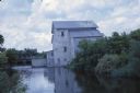
| Description: | Landscape photograph by Sid Boyum of a fisherman on the bank of Big Spring Creek near a power house and dam. The fisherman to the right blends into the bui... |

| Date: | |
|---|---|
| Description: | View from a bluff overlooking a glacial drumlin and a hill in the distance. Identified via caption as Roche-a-Cri. |
| Date: | 1910 |
|---|---|
| Description: | A group of three men and four women, probably members of the Von der Sump family, posing for a casual portrait on a rock formation at the Wisconsin Dells. |
| Date: | 06 1964 |
|---|---|
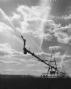
| Description: | Irrigation sprinklers spraying water onto a field near Grand Marsh. |
| Date: | 07 09 1911 |
|---|---|
| Description: | Text on front reads: "Chimney Rock, Dells of the Wisconsin." The rock formation Chimney Rock overhanging the Wisconsin River. Bluffs are on the left and th... |
If you didn't find the material you searched for, our Library Reference Staff can help.
Call our reference desk at 608-264-6535 or email us at: