 Filter: Categories of Wisconsin Historical Images
Filter: Community of Waupaca
Filter: Year of 1800-1899
Filter: Categories of Wisconsin Historical Images
Filter: Community of Waupaca
Filter: Year of 1800-1899
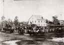
| Date: | 1870 |
|---|---|
| Description: | View of an unidentified ceremony taking place at the public square on the steps of the original Waupaca County Courthouse. |

| Date: | 1896 |
|---|---|
| Description: | A map of the Chain-O-Lakes in Waupaca, including Indian trails. The path of the Waupaca Electric Railway from the Grand View Hotel to the Wisconsin Central... |
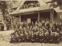
| Date: | 1890 |
|---|---|
| Description: | Outdoor group portrait of the reunion of the 21st Wisconsin Infantry at the Soldier's Home. |
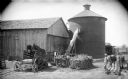
| Date: | 1895 |
|---|---|
| Description: | A twenty-five foot high round silo featured on the farm of F.D. Parish, 4.5 miles southeast of Waupaca. The silo is twenty feet in diameter. Two men are ge... |

| Date: | 1898 |
|---|---|
| Description: | This 1896 map of the Chain-O-Lakes region of Waupaca County, Wisconsin, shows the lakes and streams, some topography, archaeological sites, roads, railroad... |

| Date: | 1898 |
|---|---|
| Description: | This 1898 map shows the contour depths of the Chain O' Lakes in Waupaca County, Wisconsin, and includes 15 cross sections of the lakes. Roads, parks, the W... |
If you didn't find the material you searched for, our Library Reference Staff can help.
Call our reference desk at 608-264-6535 or email us at:
