Filter: Categories of Wisconsin Historical Images
Filter: Community of Washburn
Filter: Subject of transportation
Filter: Categories of Wisconsin Historical Images
Filter: Community of Washburn
Filter: Subject of transportation
| Date: | |
|---|---|
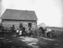
| Description: | The family of French-Canadian immigrant Peter Lagacy, posing with produce, including a large cabbage, potatoes, and carrots, in front of their log farm hom... |

| Date: | 1886 |
|---|---|
| Description: | Bird's-eye map of Washburn on Lake Superior. There is an inset of Washburn, Chequamagon and the Apostle Islands. |

| Date: | 1896 |
|---|---|
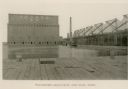
| Description: | Bird's-eye view of Washburn, with twenty vignettes around side, water in foreground with docks and lumber corral. Thirty-three locations identified in key ... |

| Date: | 1910 |
|---|---|
| Description: | Bird's-eye view looking east, with Washburn Harbor at center and Chequamegon Bay in Lake Superior covering most of the upper image. Streets with buildings... |
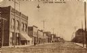
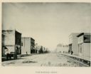
| Date: | |
|---|---|
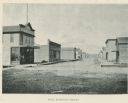
| Description: | View down street with numerous businesses on both sides along the sidewalks. Caption reads: "Street Scene, Washburn, Wisconsin. |
| Date: | 1904 |
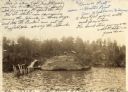
|---|---|
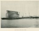
| Description: | View across water towards Brower Park near Houghton Point. |

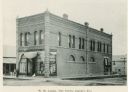
| Date: | |
|---|---|
| Description: | Exterior view of the Washburn City Hall, which houses the Bank of Washburn. |
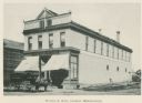
| Date: | |
|---|---|
| Description: | Exterior view of W.H. Lemke's store, which features dry goods, carpet, and more. |
| Date: | |
|---|---|
| Description: | Exterior view of Walter S. Rait's Merchandise. |
| Date: | |
|---|---|
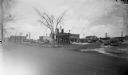
| Description: | East Bayfield Street including a wagon on the street and a livery. |
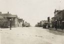
| Date: | 1916 |
|---|---|
| Description: | View looking down the center of road, with storefronts and dwellings on both sides. Automobiles and horse-drawn vehicles are parked at various points along... |
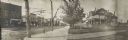
| Date: | |
|---|---|
| Description: | Panoramic view of a street corner. Commercial buildings are along the street on the left, including D.W. Corning Groceries. A large group of people are on ... |
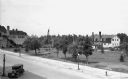
| Date: | 1932 |
|---|---|
| Description: | Elevated view of one automobile parked on Main Street near a park (the Legion Memorial Park), trees, an American flag, street lights, and various buildings... |
| Date: | 1935 |
|---|---|
| Description: | Aerial view, taken from an airplane, overlooking the streets, houses, stores, trees and railroad cars. |
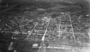
| Date: | 1938 |
|---|---|
| Description: | View across road of the Route 66 service station. Automobiles and a Phillips 66 Chequamegon Oil Co. truck are in the parking lot. Signs around the Route 66... |
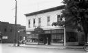
| Date: | 1936 |
|---|---|
| Description: | View across street of a wooden corner building with large plate glass windows and a sign advertising Meyer's Cafe. An advertisement is painted on the side ... |
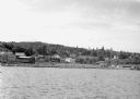
| Date: | 1942 |
|---|---|
| Description: | View from Lake Superior looking at the shoreline of Washburn. Houses, buildings, people, cars and trees are visible on shore. |
If you didn't find the material you searched for, our Library Reference Staff can help.
Call our reference desk at 608-264-6535 or email us at: