Filter: Categories of Wisconsin Historical Images
Filter: Community of Trempealeau
Filter: Subject of human settlements
Filter: Categories of Wisconsin Historical Images
Filter: Community of Trempealeau
Filter: Subject of human settlements
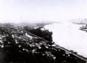
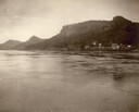
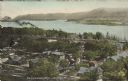
| Date: | 1907 |
|---|---|
| Description: | Elevated view from first peak of Trempealeau, Wisconsin. |
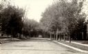
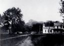
| Date: | 1920 |
|---|---|
| Description: | View down center of tree-lined road in Trempealeau. Commercial buildings are in the distance. |
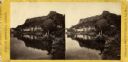
| Date: | 1890 |
|---|---|
| Description: | A stereograph of Trempealeau from the river. |
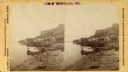
| Date: | 1890 |
|---|---|
| Description: | Stereograph of Trempealeau from the river with two men in a boat in the foreground. |
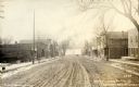
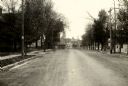
| Date: | 1907 |
|---|---|
| Description: | Fourth street in Trempealeau, Wisconsin. |
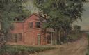
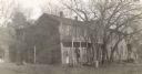
| Date: | 1931 |
|---|---|
| Description: | Drawing of the Melchoir House, which was a popular hostelry and brewery operated by Jacob Melchoir. It later became an Indian boarding house. |
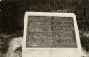
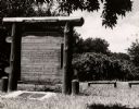
| Date: | 1926 |
|---|---|
| Description: | A marker commemorating the French fort erected by Rene Godefrey, Sieur de Linctot, which existed on this site between 1731-1736. It is thought that the sit... |
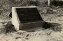
| Date: | 1926 |
|---|---|
| Description: | A marker commemorating the French fort erected by Rene Godefrey, Sieur de Linctot, which existed on this site between 1731-1736. It is thought that the sit... |
| Date: | 1951 |
|---|---|
| Description: | A marker commemorating the French fort erected by Rene Godefrey, Sieur de Linctot, which exisited on this site between 1731-1736. It is thought that the si... |
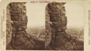
| Date: | 1890 |
|---|---|
| Description: | Stereograph view from the bluffs looking down over a town. A man is standing on the edge of the side of the formation, about halfway up, above treeline, an... |

| Date: | 1920 |
|---|---|
| Description: | This blue print map shows landownership between 1913 and 1916, topography, railroads, and roads. The map covers the vicinity of Perrot State Park. |
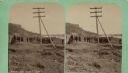
| Date: | 04 18 1888 |
|---|---|
| Description: | Stereograph of fireplace ruins on the site of an old French fort, possibly built by Nicholas Perrot. There is an electric pole behind the fireplace and a g... |
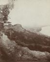
| Date: | |
|---|---|
| Description: | View of Trempealeau from bluffs north of the town, looking south towards the Mississippi river. |
| Date: | 1936 |
|---|---|
| Description: | Text on front reads: "Trempealeau Wis. on the Great River Road overlooking Lock & Dam No. 6 on the Upper Mississippi." On reverse: "Lock & Dam No. 6, one o... |

| Date: | 1950 |
|---|---|
| Description: | Text on front reads: "Main Street - Trempealeau, Wisconsin." On reverse: "On the Grand Old Mississippi and the Great River Road near Perrot State Park and ... |
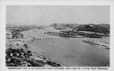
| Date: | 1920 |
|---|---|
| Description: | Text on front reads: "Trempealeau, Wis., on-the-Mississippi." Aerial view of the town on the Mississippi River. |
If you didn't find the material you searched for, our Library Reference Staff can help.
Call our reference desk at 608-264-6535 or email us at: