 Filter: Categories of Wisconsin Historical Images
Filter: Community of La Crosse
Filter: Creator Name of La Crosse Chamber of Commerce
Filter: Categories of Wisconsin Historical Images
Filter: Community of La Crosse
Filter: Creator Name of La Crosse Chamber of Commerce

| Date: | 1953 |
|---|---|
| Description: | Aerial view of La Crosse and the Mississippi River. In the foreground is the new bridge as of 1953. |
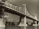
| Date: | 09 1939 |
|---|---|
| Description: | View from shoreline towards the bridge over the Mississippi River in La Crosse. |
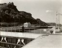
| Date: | 1935 |
|---|---|
| Description: | Locks on the Mississippi River, a nine foot channel. A man is standing above the locks. Bluffs are in the background. |

| Date: | 1950 |
|---|---|
| Description: | This map is intended for tourists visiting La Crosse. The front of the map provides extensive text on attractions and activities in La Crosse while the bac... |

| Date: | 1956 |
|---|---|
| Description: | This map is intended for tourists of La Crosse. The front of the map is text about attractions, activities, and accommodations in La Crosse. The back is th... |

| Date: | 1927 |
|---|---|
| Description: | This map includes an index and highways marked in red. Attractions on the map include: Four Mile House, Cold Springs, Grand Crossing Station, Coleman Sloug... |
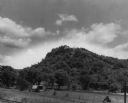
| Date: | 1946 |
|---|---|
| Description: | View of a wooded hill. Two small buildings, a fence, and railroad tracks are in the foreground. Caption reads: "Grandad Bluff, near La Crosse, Wis. This bl... |
If you didn't find the material you searched for, our Library Reference Staff can help.
Call our reference desk at 608-264-6535 or email us at: