Filter: Categories of Wisconsin Historical Images
Filter: Community of Jefferson
Filter: Subject of botany
Filter: Categories of Wisconsin Historical Images
Filter: Community of Jefferson
Filter: Subject of botany

| Date: | 1870 |
|---|---|
| Description: | Although the first European settlement in Jefferson was in 1836, the Village of Jefferson was first incorporated as a city in 1878. Made eight years earlie... |

| Date: | 1893 |
|---|---|
| Description: | Bird's-eye map of Jefferson, looking north. Crayfish River at left and center, Rock River from upper center to bottom center, joins at left of center; thir... |
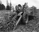
| Date: | 1949 |
|---|---|
| Description: | Farmer Dale Eisenman, Jefferson, Oregon, field tests pre-production Model 24-SC corn picker attached to Farmall H tractor on the farm of Douglas Bradley. C... |
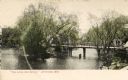
| Date: | 1905 |
|---|---|
| Description: | Elevated view of a bridge in Jefferson. Caption reads: "'The Little Red Bridge,' Jefferson, Wis." |

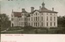
| Date: | 1905 |
|---|---|
| Description: | View towards the court house. Caption reads: "Court House, Jefferson, Wis." |

| Date: | 1905 |
|---|---|
| Description: | View towards the court house. Snow is on the ground, and a windmill is on the right. Caption reads: "Jefferson County Court House, Jefferson, Wis." |
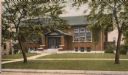
| Date: | 1905 |
|---|---|
| Description: | View of the school. Caption reads: "'High School,' Jefferson, Wis." |
| Date: | 1905 |
|---|---|
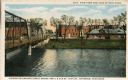
| Description: | View with the Milwaukee Street Bridge on the left, and on the opposite shoreline is the Chicago & Northwestern Railway Station. Caption at top reads: "View... |

| Date: | |
|---|---|
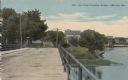
| Description: | View across water towards the bridge across the Rock River. An industrial building is to the right of the bridge. Caption reads: "The Bridge Across Rock Ri... |
| Date: | 1910 |
|---|---|
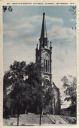
| Description: | View towards the church on a hill. There is a wide set of stairs that leads up to the entrance. Caption reads: "St. John-the-Baptist Catholic Church, Jeffe... |

| Date: | 1910 |
|---|---|
| Description: | The Stoppenbach residence at 244 E. Racine Street. Snow is on the ground and on the trees. |
| Date: | 1905 |
|---|---|
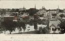
| Description: | Colorized elevated view of Jefferson with numerous churches, businesses and residential homes, and a body of water in the foreground. Caption reads: "Secti... |
| Date: | 1910 |
|---|---|
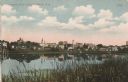
| Description: | View of Jefferson across the Rock River. Caption reads: "Panoramic View of Jefferson, Wis." |
| Date: | |
|---|---|
| Description: | View down Crawfish Bridge, with a horse-drawn buggy approaching the bridge. Buildings and trees are along the river on the right. Caption reads: "View from... |
| Date: | |
|---|---|
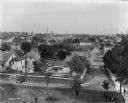
| Description: | Elevated view of the town, probably from the west bank of the Rock River. Pedestrians are walking through a park in the foreground. |
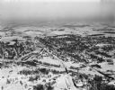
| Date: | 01 22 1949 |
|---|---|
| Description: | Aerial photograph of the city of Jefferson. |
| Date: | |
|---|---|
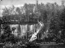
| Description: | A narrow rustic bridge crossing a pond in a wooded area known as Lovers' Walk. Caption reads: "Lovers' Walk, Near Mt. Pleasant House, Jefferson, Mass." |
If you didn't find the material you searched for, our Library Reference Staff can help.
Call our reference desk at 608-264-6535 or email us at: