 Filter: Categories of Wisconsin Historical Images
Filter: Community of Hayward
Filter: Type of Map or Atlas
Filter: Categories of Wisconsin Historical Images
Filter: Community of Hayward
Filter: Type of Map or Atlas
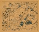
| Date: | 1940 |
|---|---|
| Description: | This map shows cities and villages, roads, railroads, and lakes and streams in northern Sawyer, northeastern Washburn, southeastern Douglas, and southern B... |

| Date: | 1949 |
|---|---|
| Description: | This 1949 tourism brochure for the Hayward region includes a directory of members of the Hayward Lakes Resort Association, color illustrations, descriptive... |

| Date: | 1915 |
|---|---|
| Description: | This map shows a plat of city, wards, sections, land ownership by name, local streets, roads, railroads, local businesses, schools, and parks. This map is ... |

| Date: | 1970 |
|---|---|
| Description: | This map shows lot and block numbers, city limits, cemeteries, schools, outdoor theater, Lumberjack Bowl, and Historyland among other attractions. |
If you didn't find the material you searched for, our Library Reference Staff can help.
Call our reference desk at 608-264-6535 or email us at: