 Filter: Categories of Wisconsin Historical Images
Filter: Community of Gettysburg
Filter: Year of 1800-1899
Filter: Categories of Wisconsin Historical Images
Filter: Community of Gettysburg
Filter: Year of 1800-1899
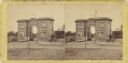
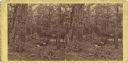
| Date: | 1863 |
|---|---|
| Description: | Stereograph of Gettysburg battlefield showing trees and a stump. Handwritten on reverse, "On the right of our line." This is probably a reference to the te... |
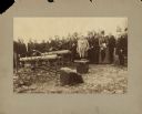
| Date: | 05 1887 |
|---|---|
| Description: | Members of the Wisconsin commission to locate monuments gather on the battlefield at Little Round Top. |
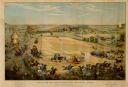
| Date: | 1886 |
|---|---|
| Description: | Color lithographed color advertising poster showing a McCormick grain binder at the Civil War battle of Gettysburg. The poster was based on a cyclorama by ... |
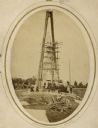
| Date: | 1869 |
|---|---|
| Description: | Governor Lucius Fairchild of Wisconsin and an unidentified group visiting the still uncompleted national monument at Gettysburg, Pennsylvania in 1869. Fair... |
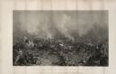
| Date: | 1863 |
|---|---|
| Description: | An engraving of the Battle of Gettysburg, after the painting by P.F. Rothermel. |
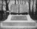
| Date: | 1890 |
|---|---|
| Description: | "Commands Honored" monument in the form of a large bronze book opened to pages reading "High Water Mark on the Rebellion" and "Repulse of Longstreet's Assa... |

| Date: | 1864 |
|---|---|
| Description: | This map of the Battle of Gettysburg indicates Union positions in red and Confederate positions in blue. Also shown are artillery positions, roads, railroa... |

| Date: | 1876 |
|---|---|
| Description: | Detailed topographic map of the Gettysburg battlefield created thirteen years after the battle. This map shows day one of the battle. The map shows drainag... |

| Date: | 1863 |
|---|---|
| Description: | These detailed topographical maps of the Battle of Gettysburg show drainage, vegetation, roads, railroads, fences, houses with names of residents, and a de... |

| Date: | 1863 |
|---|---|
| Description: | These detailed topographical maps of the Battle of Gettysburg show drainage, vegetation, roads, railroads, fences, houses with names of residents, and a de... |

| Date: | 1863 |
|---|---|
| Description: | These detailed topographical maps of the Battle of Gettysburg show drainage, vegetation, roads, railroads, fences, houses with names of residents, and a de... |

| Date: | 1863 |
|---|---|
| Description: | This map shows drainage, vegetation, roads, railroads, fences, dwellings with names of inhabitants, and land owned by the United States. Union and Confeder... |
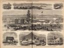
| Date: | 12 05 1863 |
|---|---|
| Description: | Engraving of the dedication ceremony for the Soldiers' National Cemetery, November 19,1863, that appeared in "Frank Leslie's Illustrated Newspaper." It was... |
| Date: | 07 1863 |
|---|---|
| Description: | Stereograph of the Evergreen Cemetery, a private cemetery in Gettysburg opened in 1855. Because of its location on Cemetery Hill, the highest point in the ... |
| Date: | 07 1863 |
|---|---|
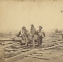
| Description: | Stereograph of three Confederate soldiers captured during the Battle of Gettysburg. This photograph was taken by Mathew Brady a few days after the battle. ... |
| Date: | 06 1863 |
|---|---|
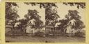
| Description: | Stereograph of General Lee's headquarters at Gettysburg, photographed by Mathew Brady a few days after the battle. Two women appear on the lower right. |
| Date: | 07 1863 |
|---|---|
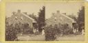
| Description: | Stereograph of the farmhouse of Abram Bryant, a free black man who lived near Gettysburg, Pennsylvania. An African American man is standing near the porch ... |
| Date: | 07 1863 |
|---|---|
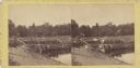
| Description: | Stereograph of McPherson's Woods, where General John Reynolds, commanding the First Corps of which Wisconsin's 2nd, 6th, and 7th regiments were a part, was... |
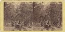
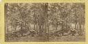
| Date: | 07 1863 |
|---|---|
| Description: | Gettysburg stereograph that Lucius Fairchild of the 2nd Wisconsin identified as "the right of the Union line." It shows the wooded terrain of Culp's Hill ... |
| Date: | 07 1863 |
|---|---|
| Description: | A stereograph made by Mathew Brady about two weeks after the battle of Gettysburg, showing his two assistants gazing eastward from the extreme right of the... |
If you didn't find the material you searched for, our Library Reference Staff can help.
Call our reference desk at 608-264-6535 or email us at: