 Filter: Categories of Wisconsin Historical Images
Filter: Community of Eau Claire
Filter: Categories of Wisconsin Historical Images
Filter: Community of Eau Claire
| Date: | 08 18 1944 |
|---|---|
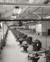
| Description: | Elevated view of a long row of heavy service tire building machines waiting to be installed in the Gillette Tire Plant. |

| Date: | 1920 |
|---|---|
| Description: | Exterior view of International Harvester's Eau Claire branch house. Another building is in the background. |

| Date: | |
|---|---|
| Description: | Letterhead of the City of Eau Claire Public Schools, with a three-quarter view of the High School building, and names of officers of the school district an... |
| Date: | |
|---|---|
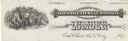
| Description: | Letterhead of Northwestern Lumber Company of Eau Claire, Wisconsin, manufacturer of "Lath Shingles & Pickets," with two men in the woods, one poised with a... |
| Date: | |
|---|---|
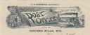
| Description: | Letterhead of the Post Office in Porters Mills, Wisconsin, with a man putting mail into post office boxes, a padlocked mail bag that serves as a signboard ... |

| Date: | 1928 |
|---|---|
| Description: | Label submitted to the state of Wisconsin for trademark registration. "Viking brand, Malt Syrup, distributed by E-C products Co." A large viking ship is pr... |

| Date: | |
|---|---|
| Description: | Letterhead of the Eau Claire Transportation Company, "urban passenger carriers," with a three-quarter view of a red and yellow city bus marked "Olson Stree... |

| Date: | |
|---|---|
| Description: | Letterhead of the Eau Claire Ice Company, with an elongated capital letter "I" in the company name, a cube of "Pure Ice" and a lump of "Clean Coal," and a ... |
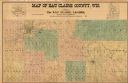
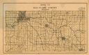
| Date: | 1902 |
|---|---|
| Description: | This 1902 map of Eau Claire County, Wisconsin, shows the township and range grid, towns, sections, landownership and acreages, roads and railroads, and sel... |
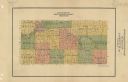
| Date: | 1926 |
|---|---|
| Description: | Map of Eau Claire County, Wisconsin Shows highways, railroads, hydrography, and townships. |
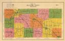
| Date: | 1911 |
|---|---|
| Description: | Map shows townships and sections, roads, and railroads. "W.W. Downs, attorney-at-law, Eau Claire, Wis." |
| Date: | 1933 |
|---|---|
| Description: | Map shows roads, township and range, water, and cultural features. |
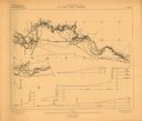
| Date: | 1906 |
|---|---|
| Description: | Portion of title: Eau Claire River, Wisconsin. Relief shown by contours and spot heights. Contour interval on land 5 feet. Contour interval on river surfac... |

| Date: | 1875 |
|---|---|
| Description: | Shows land ownership by name, local streets, buildings, cemeteries, Chippewa River, and Half Moon Lake. Includes 1 inset map of Eau Claire. Also includes c... |

| Date: | 1877 |
|---|---|
| Description: | Relief shown by hachures. Shows land ownership by name, wards, railroads, mills, dams, city limits, Chippewa River, and Half Moon Lake. Includes index of m... |

| Date: | 1877 |
|---|---|
| Description: | Relief shown by hachures. Shows land ownership by name, wards, railroads, mills, dams, city limits, Chippewa River, and Half Moon Lake. Includes index of m... |

| Date: | 1889 |
|---|---|
| Description: | Shows city limits, railroads, mills, schools, cemeteries, dams, parks, lumber yards, log canals, log reservoir, Chippewa River, Eau Claire River, and Half ... |

| Date: | 1964 |
|---|---|
| Description: | Shows local streets, bus routes, highways, airport, Dells Pond, Half Moon Lake, Chippewa River, and Eau Claire River. Includes 2 inset maps: Location map a... |
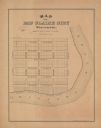
| Date: | 1900 |
|---|---|
| Description: | Shows plat of town, local streets, town sections, and Chippewa River. Streets running horizontally begin at the top with "Lake Street" and end with "Water ... |

| Date: | 1926 |
|---|---|
| Description: | Relief shown by hachures. Shows local streets, roads, railroads, businesses, Half Moon Lake, Chippewa River, and log reservoir. |
If you didn't find the material you searched for, our Library Reference Staff can help.
Call our reference desk at 608-264-6535 or email us at: