Filter: Categories of Wisconsin Historical Images
Filter: Community of Cadott
Filter: Subject of streets
Filter: Categories of Wisconsin Historical Images
Filter: Community of Cadott
Filter: Subject of streets

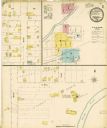
| Date: | 1900 |
|---|---|
| Description: | This photocopy map shows block and lot numbers with landowner names, additions, selected buildings, and the Yellow River. |
If you didn't find the material you searched for, our Library Reference Staff can help.
Call our reference desk at 608-264-6535 or email us at: