Filter: Categories of Wisconsin Historical Images
Filter: Community of Cadott
Filter: Subject of rivers
Filter: Categories of Wisconsin Historical Images
Filter: Community of Cadott
Filter: Subject of rivers
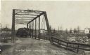
| Date: | 05 03 1908 |
|---|---|
| Description: | Photographic view of the Yellow River Bridge. A horse-drawn wagon full of hay is crossing the bridge. Houses and trees can be seen on the far side of the r... |

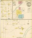
| Date: | 1900 |
|---|---|
| Description: | This photocopy map shows block and lot numbers with landowner names, additions, selected buildings, and the Yellow River. |
If you didn't find the material you searched for, our Library Reference Staff can help.
Call our reference desk at 608-264-6535 or email us at: