 Filter: Categories of Wisconsin Historical Images
Filter: Community of Blue Mounds
Filter: Year of 1800-1899
Filter: Categories of Wisconsin Historical Images
Filter: Community of Blue Mounds
Filter: Year of 1800-1899

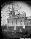
| Date: | 07 1838 |
|---|---|
| Description: | A map diagram of Indian effigy mounds seven miles east of Blue Mounds in the Wisconsin Territory. |
| Date: | 1879 |
|---|---|
| Description: | Harold and Gunhild Mickelson with five of their daughters (Bertha Mickelson Bragger and her husband are standing on the right), in Section 23 of the Town o... |
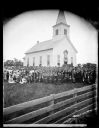
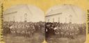
| Date: | 08 30 1876 |
|---|---|
| Description: | The congregation of the East Blue Mounds Lutheran Church and visiting ministers are gathered for the church dedication. The church was formerly Norsk Evang... |
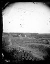
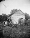
| Date: | 1873 |
|---|---|
| Description: | View down a rocky rural lane near West Blue Mounds. Zigzag stake and rider split-rail fencing enclose a farmstead, which includes a barn, a frame house, ha... |
| Date: | 1871 |
|---|---|
| Description: | Andrew Dahl's wagon is on the side of a two-story log house in Blue Mounds. On one side of the wagon cover is "A.L. Dahl Landscape Photographer." On the ba... |
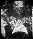
| Date: | 1876 |
|---|---|
| Description: | "View of the Dining Table" from the "Dedication of Blue Mounds Church" section of Dahl's 1877 "Catalogue of Stereoscopic Views", showing a long banquet tab... |
| Date: | 08 30 1876 |
|---|---|
| Description: | "View of the interior of the church" from the "Dedication of Blue Mounds Church" section of Dahl's 1877 "Catalogue of Stereoscopic Views." The church was d... |
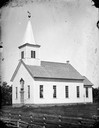
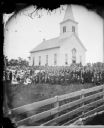
| Date: | 1872 |
|---|---|
| Description: | East Blue Mounds Lutheran Church, built in 1868. The church was formerly the Norsk Evangelisk Lutheranisk Kirke. |
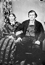
| Date: | 1876 |
|---|---|
| Description: | Half of a double portrait of Ever or Iver B. Lund and wife, of Blue Mounds, Blue Valley. He was a tailor by trade. Note his withered left leg. |
| Date: | 08 30 1876 |
|---|---|
| Description: | "View of the ministers present" from the "Dedication of Blue Mounds Church" section of Dahl's 1877 "Catalogue of Stereoscopic Views." The congregation of t... |
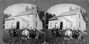
| Date: | 1872 |
|---|---|
| Description: | Students and teachers sitting in front of the Blue Mounds school house. |
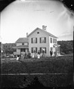
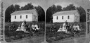
| Date: | 1875 |
|---|---|
| Description: | A family group of eleven sits around a table with a pitcher and books before the farm house of Knud Gjesma. |
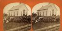
| Date: | 08 30 1876 |
|---|---|
| Description: | The congregation of the East Blue Mounds Lutheran Church and visiting ministers are gathered for the church dedication. The church was formerly Norsk Evang... |
| Date: | 1876 |
|---|---|
| Description: | East Blue Mounds Lutheran Church, formerly Norsk Evangelisk Kirke, built in 1868. The graves of Andreas L. Dahl's mother, Berthe Nelsdatter (Lund) Dahlen, ... |
| Date: | 08 30 1876 |
|---|---|
| Description: | The congregation of the East Blue Mounds Lutheran Church and visiting ministers are gathered for the church dedication. The church was formerly Norsk Evang... |
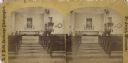
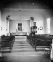
| Date: | 08 30 1876 |
|---|---|
| Description: | Interior view of Blue Mounds Church. Built in 1868, the church was originally named the Norsk Evangelisk Kirke. |
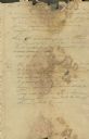
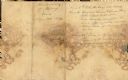
| Date: | 06 23 1832 |
|---|---|
| Description: | Document written by Ebenezer Brigham listing events at Fort Blue Mounds. |
| Date: | 06 23 1832 |
|---|---|
| Description: | Document written by Ebenezer Brighman listing occurrences at Fort Blue Mounds. |

| Date: | 1867 |
|---|---|
| Description: | This 1867 manuscript map by Increase Lapham shows the topography and geology of the Blue Mounds region in the Town of Brigham in Iowa County and the towns ... |

| Date: | 1864 |
|---|---|
| Description: | This map is pen and watercolor on paper and shows profile and geological formation of Blue Mound and location of Arnold’s Hotel and Brigham Lead Mines. |
If you didn't find the material you searched for, our Library Reference Staff can help.
Call our reference desk at 608-264-6535 or email us at: