 Filter: Categories of Wisconsin Historical Images
Filter: Community of Aztalan
Filter: Type of Map or Atlas
Filter: Categories of Wisconsin Historical Images
Filter: Community of Aztalan
Filter: Type of Map or Atlas
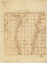
| Date: | 1860 |
|---|---|
| Description: | This manuscript map shows the surveyed areas of the Town of Aztalan, Jefferson County, Wisconsin. Acreage of the surveyed parcels is given and lakes and st... |

| Date: | 1940 |
|---|---|
| Description: | This map of Aztalan is pencil and ink on paper. The map shows streets, local businesses, churches, houses, and the Crawfish River. The map reads: "Informat... |
If you didn't find the material you searched for, our Library Reference Staff can help.
Call our reference desk at 608-264-6535 or email us at:
