 Filter: Categories of Wisconsin Historical Images
Filter: Creator Name of Owen, David Dale
Filter: Subject of land
Filter: Categories of Wisconsin Historical Images
Filter: Creator Name of Owen, David Dale
Filter: Subject of land
| Date: | |
|---|---|
| Description: | Geological map. |
| Date: | 1851 |
|---|---|
| Description: | Owen Geological Map of Wisconsin. |

| Date: | 1844 |
|---|---|
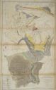
| Description: | A hand-colored map and chart showing a geological cross-section from Rockingham, in present-day Scott County, Iowa, through Blue Mounds to the Wisconsin Ri... |

| Date: | 1852 |
|---|---|
| Description: | Hand-colored maps and a series of geological cross sections of the Mississippi River between the Falls of St. Anthony and the mouth of the Wisconsin River ... |

| Date: | 1847 |
|---|---|
| Description: | A geological, hand-colored map of Wisconsin north and west of the Wisconsin River, as well as portions of eastern Minnesota and Iowa from the Mississippi t... |

| Date: | 08 1960 |
|---|---|
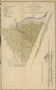
| Description: | This map shows a detailed account of southwestern Wisconsin. Individual settlers, the type of trees that grow in given areas, the quality of the soil (labe... |
If you didn't find the material you searched for, our Library Reference Staff can help.
Call our reference desk at 608-264-6535 or email us at: