 Filter: Categories of Wisconsin Historical Images
Filter: Creator Name of Mitchell, Samuel Augustus
Filter: Subject of rivers
Filter: Categories of Wisconsin Historical Images
Filter: Creator Name of Mitchell, Samuel Augustus
Filter: Subject of rivers

| Date: | 1848 |
|---|---|
| Description: | In 1849, northern Wisconsin was composed of huge sectional regions such as Chippewa, Portage, Brown and Crawford, whereas southern Wisconsin was constitute... |

| Date: | 1846 |
|---|---|
| Description: | Drawn two years before Wisconsin entered statehood, this map shows the counties and towns that existed at the time, as well as known rivers and lakes. By 1... |

| Date: | 1847 |
|---|---|
| Description: | In 1847, a year before Wisconsin entered statehood, most of the county shapes in southeastern and southern Wisconsin looked the same as they do today, wher... |

| Date: | 1850 |
|---|---|
| Description: | A hand-colored map showing portions of present-day Iron and Vilas counties north of the Manitowish River as part of the Upper Peninsula of Michigan. The Wi... |

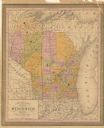
| Date: | 1852 |
|---|---|
| Description: | A hand-colored map showing portions of present-day Iron and Vilas counties north of the Manitowish River as part of the Upper Peninsula of Michigan. The Wi... |

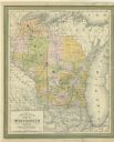
| Date: | 1852 |
|---|---|
| Description: | Map shows Wisconsin counties by color and includes rivers, lakes and some cities. This information is also given for eastern Minnesota and northern Illinoi... |
| Date: | 1854 |
|---|---|
| Description: | This map shows portions of present-day Iron and Vilas counties north of the Manitowish River as part of the Upper Peninsula of Michigan. The Wisconsin coun... |

| Date: | 1866 |
|---|---|
| Description: | A pen on paper, hand-drawn and colored map of Wisconsin and Michigan, showing counties, cities and villages, rivers and lakes, as well as railroads are in ... |

| Date: | 1866 |
|---|---|
| Description: | A pen on paper, hand-drawn and colored map of Wisconsin and Michigan, showing counties, cities and villages, rivers and lakes, as well as railroads are in ... |
| Date: | 1853 |
|---|---|
| Description: | This map shows counties in pink, orange, green, and yellow. Lake Michigan and Lake Superior are labeled as well as rivers and some geographical features. M... |
If you didn't find the material you searched for, our Library Reference Staff can help.
Call our reference desk at 608-264-6535 or email us at: