 Filter: Categories of Wisconsin Historical Images
Filter: Creator Name of Draper, Lyman Copeland
Filter: Subject of maps
Filter: Categories of Wisconsin Historical Images
Filter: Creator Name of Draper, Lyman Copeland
Filter: Subject of maps

| Date: | 1780 |
|---|---|
| Description: | Plan for layout of 150,00 acres which make up Clark's Illinois Grant. |
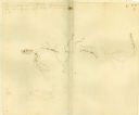
| Date: | |
|---|---|
| Description: | Plat map of Mammoth Cave. A note on the map reads: "Mrs. Campbell conjectures that this is a saltpeter cave in Green River, Kentucky. The mummy found in it... |

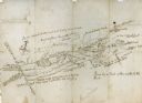
| Date: | 07 04 1776 |
|---|---|
| Description: | Hand-drawn map of the area where the Battle of Black's Fort took place. |
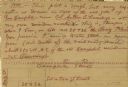
| Date: | 07 04 1776 |
|---|---|
| Description: | Notes written in red ink on the back of the map of the Battle of Black's Fort. |
| Date: | |
|---|---|
| Description: | Hand-drawn map including the Clinch River and Clinch mountain range. The Clinch River rises in Southwest Virginia near Tazewell, VA and flows southwest thr... |
If you didn't find the material you searched for, our Library Reference Staff can help.
Call our reference desk at 608-264-6535 or email us at:
