| Date: | 1655 |
|---|---|
| Description: | Map of Virginia Coast based on observations by Captain John Smith. |

| Date: | 1655 |
|---|---|
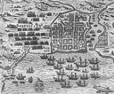
| Description: | Map from Drake Expedition, ca. 1585. |

| Date: | 1655 |
|---|---|
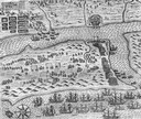
| Description: | Map from Drake Expedition in Florida, ca. 1585. |

| Date: | 02 01 1793 |
|---|---|
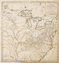
| Description: | Text in the upper right corner reads, "A Map of The Western Part of the Territories belonging to the United States of America. Drawn from the best authorit... |

| Date: | 1871 |
|---|---|
| Description: | A map of California showing railroad lines and reservations. |

| Date: | |
|---|---|
| Description: | A map captioned: "Diagram of the Region Destitute of Drift and Boulders in Wisconsin, Iowa and Minnesota." |

| Date: | 1814 |
|---|---|
| Description: | A map of the Harbour (sic) of St. Catherine (Brazil). |
If you didn't find the material you searched for, our Library Reference Staff can help.
Call our reference desk at 608-264-6535 or email us at: