Filter: Categories of Wisconsin Historical Images
Filter: COLLECTION_NAME of Commonplace Structures in Southern Wisconsin
Filter: Subject of human settlements
Filter: Categories of Wisconsin Historical Images
Filter: COLLECTION_NAME of Commonplace Structures in Southern Wisconsin
Filter: Subject of human settlements
| Date: | 12 1980 |
|---|---|
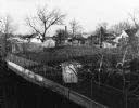
| Description: | Elevated view of backyards in a neighborhood looking over trees, a shed, and a fences. In the background are houses and a smokestack. |
| Date: | 04 1980 |
|---|---|
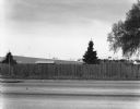
| Description: | View across stateline road towards a wooden fence lining the road on the opposite side. A few trees and buildings can be seen over the fence. |

| Date: | 1980 |
|---|---|
| Description: | Exterior of Manchester's Warehouse, located at 2013 Fish Hatchery Road. |

| Date: | 1980 |
|---|---|
| Description: | Port Pizzeria and Deli-Type Sandwiches "Home of the Big Wheel Pizza." 3077 East Washington Avenue. |

| Date: | 1980 |
|---|---|
| Description: | Four arches reach above decorative thatched windows on a Spanish style building, which was known as Licari's Tavern. 1405 Emil Street. |

| Date: | 1980 |
|---|---|
| Description: | Telephone lines and trees are in the foreground of this photograph. Tucked behind them is the St. Joseph Church, which was located at 1905 West Beltline Hi... |

| Date: | 1980 |
|---|---|
| Description: | A vacated service station at Fish Hatchery Road and Greenway Cross. |

| Date: | 1980 |
|---|---|
| Description: | Restaurant and empty parking lot at 1516 Greenway Cross. |

| Date: | 1980 |
|---|---|
| Description: | Restaurant no longer in business at 2039 Allen Boulevard. |

| Date: | 1980 |
|---|---|
| Description: | A currently closed castle-looking office, complete with turrets and stonework, located at 6414 University Avenue. |

| Date: | 1980 |
|---|---|
| Description: | A large telephone pole shadow is cast over a road in the industrial park on Evergreen Road. |

| Date: | 1980 |
|---|---|
| Description: | Shadow of billboard sign towers over the parking lot of the U-Haul 'U-Move, U-Store' Center on West Platte Drive. |

| Date: | 1980 |
|---|---|
| Description: | Elevated view of construction and development taking place in a housing community known as Tamarack Trails Subdivision. |

| Date: | 1980 |
|---|---|
| Description: | Front view of a house under construction in the Tamarack Trails Subdivision. |

| Date: | 11 1980 |
|---|---|
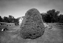
| Description: | A telephone pole emerges from a dirt mound and casts a shadow across the land. Trees and a water tower can be seen in the distance. Bible Camp Road. |

| Date: | 11 1980 |
|---|---|
| Description: | Presumably the back side of a service station located at 2663 South Stoughton Road, south of McFarland. |
| Date: | |
|---|---|
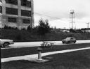
| Description: | View across road, perhaps Pleasant Street, of industrial buildings. In the foreground is a drinking fountain and picnic table. Two cars are parked nearby. |
| Date: | |
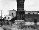
|---|---|
| Description: | View of a tall wood structure with rows of holes, perhaps a pigeon house. A cyclone fence is in front of it, and behind are industrial buildings. In the fa... |
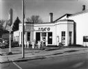
| Date: | |
|---|---|
| Description: | View from street of an old brick Ioco gas station with a few cars parked on the left. |
If you didn't find the material you searched for, our Library Reference Staff can help.
Call our reference desk at 608-264-6535 or email us at: