 Filter: Creator Name of Smith, Guy-Harold
| Date: | 1925 |
|---|---|
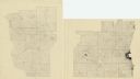
| Description: | A pen, ink and pencil on paper, hand-drawn map of southern Wisconsin that shows the area’s 1920 population density through the use of dots, dividing the co... |

| Date: | 1912 |
|---|---|
| Description: | This map is pen, ink, and pencil on tracing paper. The map was traced from U.S. Geological Survey map of Wisconsin, compiled in 1910-1911, and printed in 1... |
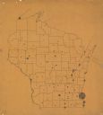
| Date: | 1912 |
|---|---|
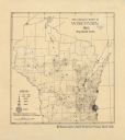
| Description: | This map is pen and ink on paper. The map was traced from a more detailed population dot map, this map shows only the major towns and cities in southern Wi... |
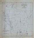
| Date: | 1905 |
|---|---|
| Description: | A map of showing the population density of foreign-born Scandinavians in Wisconsin based information from the 1905 census. The map also shows the county bo... |
| Date: | |
|---|---|
| Description: | A map indicating the population density of German-born people in Wisconsin based on the 1905 census. The map shows the county boundaries throughout the sta... |
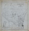
| Date: | 1905 |
|---|---|
| Description: | This map shows the German-born population in the state of Wisconsin. County boundaries are visible. In the lower left margin it includes a legend showing t... |
If you didn't find the material you searched for, our Library Reference Staff can help.
Call our reference desk at 608-264-6535 or email us at: